Minnesota is bracing for a major winter storm event that has already triggered school closures and travel chaos across the Twin Cities. The state’s weather systems are evolving into a complex mix of freezing rain, sleet, and snow, creating conditions that could turn roads into treacherous hazards. This isn’t just a routine winter event—it’s a critical test of preparedness and infrastructure resilience in a region known for its harsh climate.
What Exactly Makes This Winter Storm Unique?
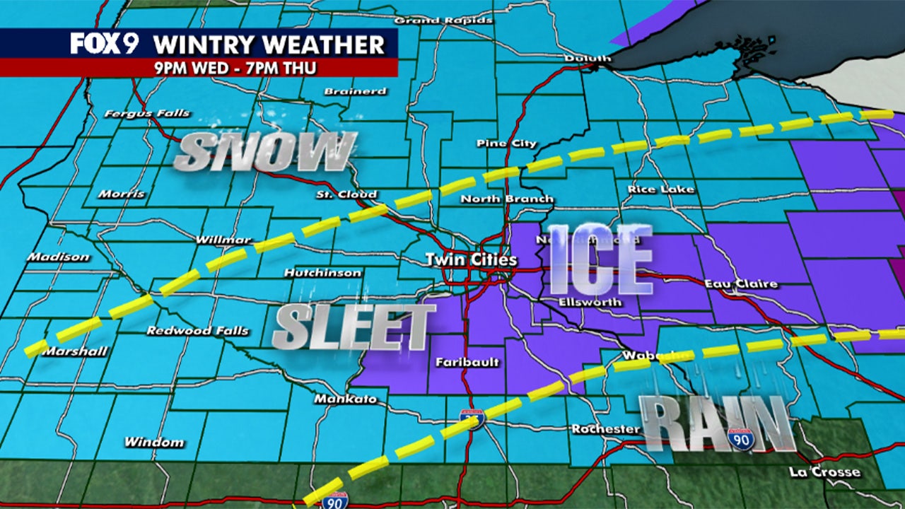
Unlike typical snowfall events, this winter storm features a wintry mix that combines freezing rain, sleet, and light snow—a phenomenon that’s particularly dangerous for transportation and infrastructure. As reported by FOX 9 Minneapolis-St. Paul, the storm is expected to hit the Twin Cities overnight Wednesday into Thursday morning with freezing rain creating icy conditions as early as Thursday morning. This type of mix is rare in the Midwest and often leads to significant disruptions.
The National Weather Service has issued a First Alert Weather Day for an ice storm, signaling that the situation is severe enough to warrant immediate action. The warning covers parts of Wisconsin and Minnesota, where temperatures are expected to drop below freezing, creating a perfect environment for ice formation.
Why School Closures Are Happening Now
- Schools in Minneapolis and St. Paul are closing early Thursday due to the threat of icy roads and slushy conditions that make travel hazardous.
- Virtual learning has been activated in several districts, with some schools switching to online classes to ensure student safety.
- The Minnesota Department of Education has issued guidance that schools may close if road conditions become too unsafe for students to travel.
These decisions are not arbitrary. The storm’s impact on transportation is already being felt, with reports of cars getting stuck in ice-covered roads and delayed travel routes. This is a critical moment for communities that rely on public transportation, as well as for parents who depend on school buses.
As the storm progresses, the National Weather Service warns that the freezing rain could persist into the holiday weekend, raising concerns about prolonged disruptions. The key to staying safe is to monitor local updates and avoid unnecessary travel. The wintry mix is the primary threat, and it’s not just about the amount of snow—it’s about the conditions that create hazardous travel scenarios.
For residents and commuters, this means planning ahead. If you live in an area with this type of storm, check your local weather app or the National Weather Service website for real-time updates. Schools and local authorities are prioritizing safety, but the storm’s impact will vary depending on your location and the severity of the conditions.